My Store
Antique Boston, Massachusetts 1894 US Geological Survey Topographic Map – Cambridge, Newton, Winchester, Lexington Lowell Concord Belmont MA
Antique Boston, Massachusetts 1894 US Geological Survey Topographic Map – Cambridge, Newton, Winchester, Lexington Lowell Concord Belmont MA
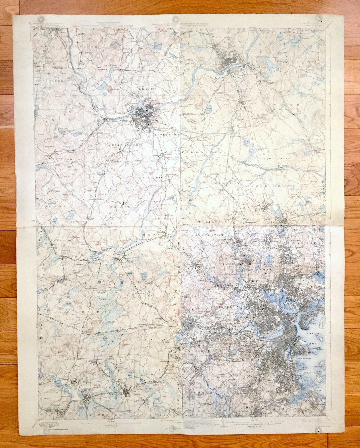
Beautiful, antique map of Boston, Massachusetts and the surrounding towns of Middlesex, Essex, Norfolk County & Suffolk County.
This map is 100% unique. It is a composite of four individual topographic maps that someone in the last century must have pieced together. The vantage is immense—all the way from Boston Harbor, west to Framingham, and North from to Nashua, NH to Boxford, MA. The four maps are authentic prints from the U.S. Geological Survey and are NOT computer reproductions.
The four quads:
TOP LEFT: Lowell, MA: 1935 edition, 1935 print
TOP RIGHT: Lawrence, MA: 1888 edition, 1929 print
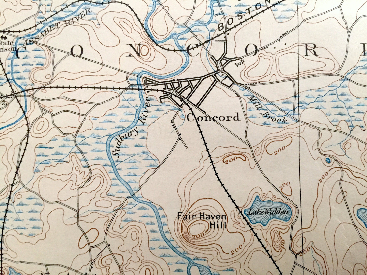
BOTTOM LEFT: Framingham, MA: 1894 edition, 1929 print
BOTTOM RIGHT: Boston, MA: 1903 edition, 1931 print
See what the Boston Metropolitan area looked like more than 120 years ago, before the land was fully developed. Lots of intricate details and geological contours. Map even has little squares for every house that existed at the time. The cartographers were very thorough back then! On the back are (*four*) descriptions of topographic symbols and map guides.
Perfect for the historian, map-lover, the curious or just as a conversation starter. Wonderful and rare. Vintage maps such as these make great gifts. This is a commanding piece.
Dimensions: 29 1/2" width x 37 3/4" height
----
Features
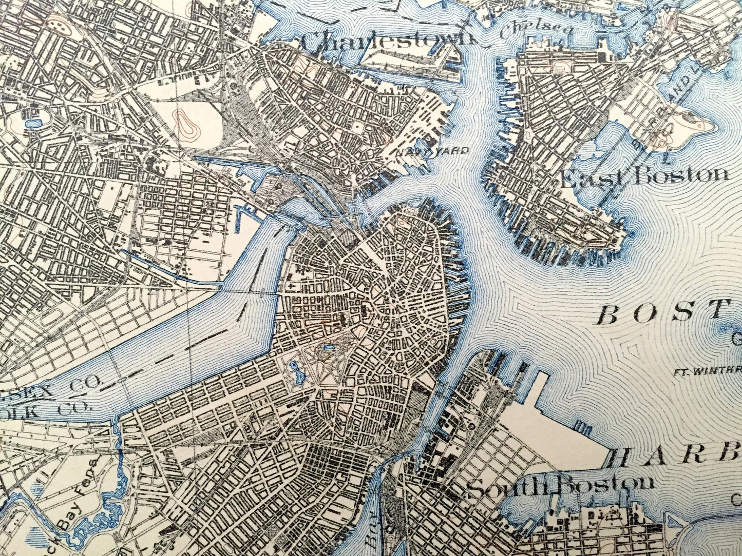
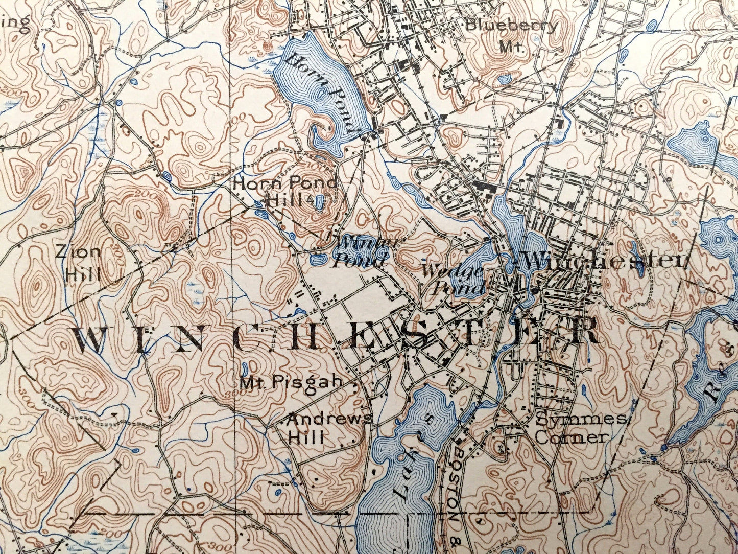
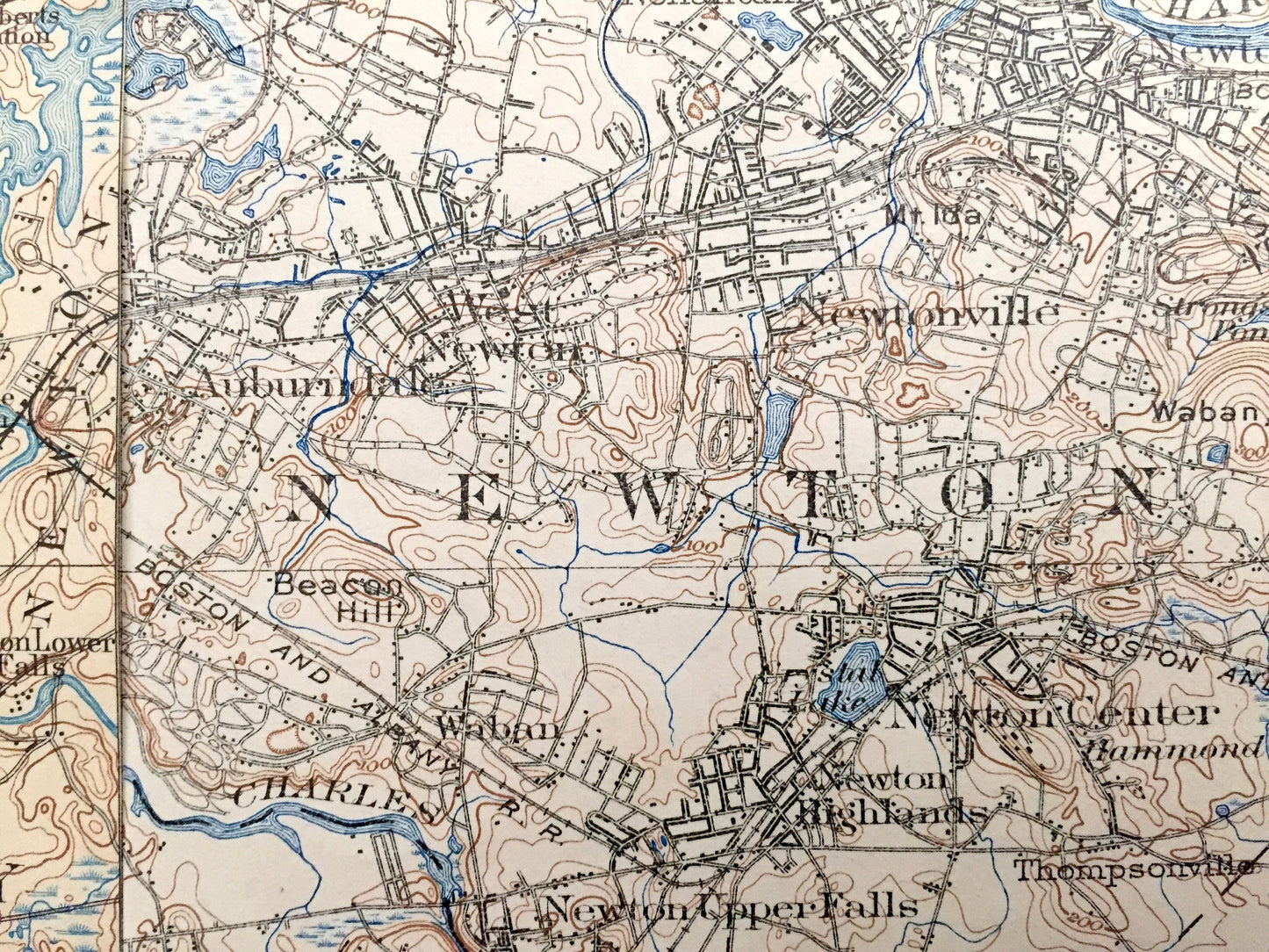
BOSTON QUAD:
Cities & Towns: Burlington, Lexington, Woburn, Winchester, Medford, Stoneham, Wakefield, Melrose, Saugus, Revere, Waltham, Arlington, Watertown, Belmont, Somerville, Cambridge, Everett, Chelsea, Charlestown, Newton, Needham, Dedham, Brookline, Boston, Hyde Park, Milton, Quincy, Cummingsville, North Lexington, East Lexington, East Woburn, West Medford, East Medford, North Saugus, Greenwood, Melrose Highlands, Wyoming, Oak Grove, Maplewood, Linden, Franklin Park, Cliftondale, Arlington Heights, Waverly, Nonantum, Auburndale, West Newton, Newtonville, Hills Crossing, Old Cambridge, Brighton, Allston, Longwood, Orient Heights, East Boston, South Boston, City Point, Newton Center, Newton Highlands, Thompsonville, Highlandville, Needham, Newton Upper Falls, Dedham Village, Boylston, Roxbury, Jamaica Plain, Forest Hills, Roslindale, West Roxbury, East Dedham, Hazelwood, Clarendon Hills, Mount Hope, Mattapan, Milton Upper Mills, Washington Village, Dorchester, Neponst, Lower Mills, Milton Mills, Atlantic, Wollaston.
Points of Interest: Middlesex County, Essex County, Norfolk County, Suffolk County, Boston Harbor, Charles River, Mystic River, Fresh Pond, South Bay, Back Bay, Spy Pond, Mystic Lakes, Spot Pond, Neponset River, Horn Pond, Chestnut Hill Reservoir, Harvard University, Fort Winthrop, Castle Island, Thompson Island, Squantum, Quincy Bay, Commercial Point, Dorchester Bay, Crystal Lake, Horn Pond Hill, Mt. Ephraim, Loring Hill, Pranker Pond, Penny Brook, Saugus River, Mystic Park, Tufts College, Clarendon Hill, Granny Hill, Whispering Hill, Cedar Hill, Owl Hill, Walnut Hill, Bald Pate Hill, Mt. Auburn Cemetery, Beacon Hill, Boston Common, Savin Hill, Breeds Island, Malden River, Zions Hill, High Rock, US Marine Hospital, Middlesex Fells, New York New Hampshire & Hartford Railroad, Boston & Albany Railroad, Boston & Maine Railroad and lots more creeks, hills, mountains, houses, churches, schools, cemeteries, train tracks and roads.
FRAMINGHAM QUAD:
Cities & Towns: Boxboro, Acton, Stow, Maynard, Concord, Bedford, Lexington, Lincoln, Hudson, Sudbury, Wayland, Weston, Waltham, Marlboro, Southboro, Framingham, Ashland, Sherborn, Natick, Dover, Needham, Newton, Wellesley, Westvale, Cochituate, Felchville, Wellesley Hills, Morseville, Charles River Village, Saxonville, Lower Village, Tower Hill.
Points of Interest: Walden Pond (written as Lake Walden), Concord River, Charles River, Assabet River, Sandy Pond, Prospect Hill, Nobscot Hill, Sudbury River, Farm Pond, Lake Cochituate, Morses Pond, Waban Lake, Train Hill, Broads Hill, Ridge Hill, Mass State Muster Grounds, Tom Hill, Strawberry Hill, Boston and Lowell Railroad, Massachusetts Central Railroad, Heathen Meadow Brook, Reeves Hill, and lots more hills, mountains, brooks, ponds, villages, roads and train tracks.
LOWELL QUAD:
Cities & Towns: MASSACHUSETTS: Dunstable, Tyngsborough, Dracut, Westford, Chelmsford, Lowell, Tewksbury, Littleton, Acton, Carlisle, Billerica, Bedford, Tyngsboro, Graniteville, West Chelmsford, North Chelmsford, Middlesex Village, Chelmsford Center, Pawtucketville, Centralville, Ayer's City, Mace's Crossing, North Billerica, Forge Village, South Chelmsford, South Billerica, Billerica Springs.
NEW HAMPSHIRE: Nashua, Pelham.
Points of Interest: Middlesex County, Merrimack River (spelled Merrimac), Tyng's Pond, Long Pond, Massapoag Pond, Concord River, Forge Pond, Nagog Pond, Hart Pond, Newfield Pond (now called Freeman Lake), Jeremy Hill, Long Hill, Oak Hill, Winter Hill, Whortleberry Hill, Tyng's Island, Duck Island, Christian Hill, Fort Hill, River Meadow Brook, Robbins Hill, Gilsons Hill, Nashoba Hill (Nashoba Valley Ski Area), New Town Hill, Spencer Brook, Nuttings Pond, Boston & Lowell Railroad, Stony Brook Railroad, Nashua Acton & Boston Railroad, Framingham & Lowell Railroad and lots more rivers, hills, islands, houses, churches, schools, cemeteries, train tracks and roads.
LAWRENCE QUAD:
Cities & Towns: Lawrence, Methuen, Bradford, Groveland, Boxford, Lawrence, North Andover, Andover, Middleton, North Reading, Reading, Lynnfield, Wakefield, Peabody, Woburn, Wilmington, Tewksbury, North Tewksbury, Billerica, Burlington.
Points of Interest: Merrimack River, Great Pond, Marbleridge Station, State Almshouse (now Tewksbury Hospital on National Register of Historic Places) Bald Pate Hill, Maine & Boston Railroad, Salem & Lawrence Railroad and many more roads, houses, reservoirs, ponds, hills, streams and stations.
----
Condition: Very Good condition, commensurate with age. This map is in incredible shape for being variously over 80 years old. Has some wear, but this will read as vintage character when framed.
----
We will happily adjust shipping price for multiple purchases. Maps are rolled up and shipped in sturdy mailing tubes. This particular map was stored with one fold and will shipped the same way.
Couldn't load pickup availability
Share