My Store
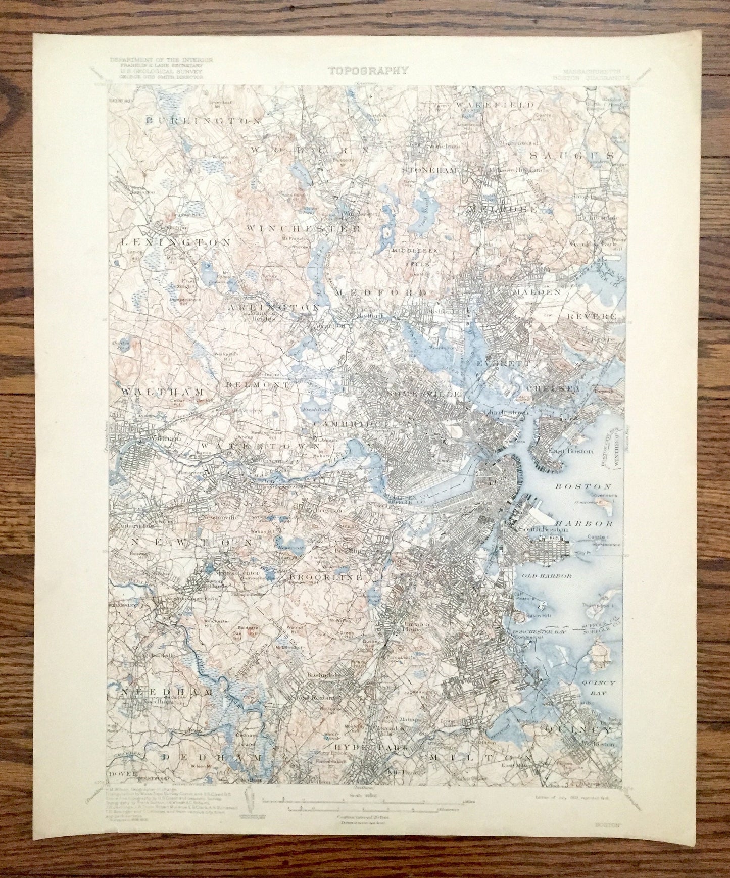
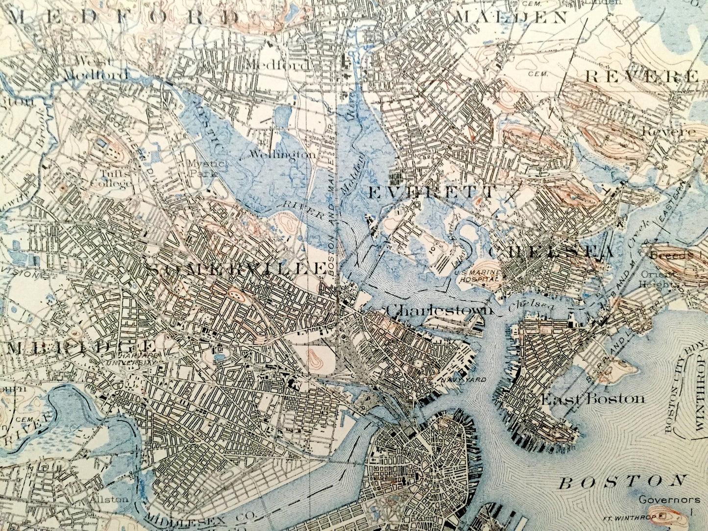
Antique Boston, Massachusetts 1903 US Geological Survey Topographic Map – Cambridge, Arlington, Brookline, Newton, Winchester, Lexington, MA
Antique Boston, Massachusetts 1903 US Geological Survey Topographic Map – Cambridge, Arlington, Brookline, Newton, Winchester, Lexington, MA
Beautiful, double-sided antique map of Boston, Massachusetts including the surrounding towns of Middlesex County, Essex County, Norfolk County and Suffolk County. This is an authentic 1903 edition, 1918 print from the U.S. Geological Survey and NOT a computer reproduction.
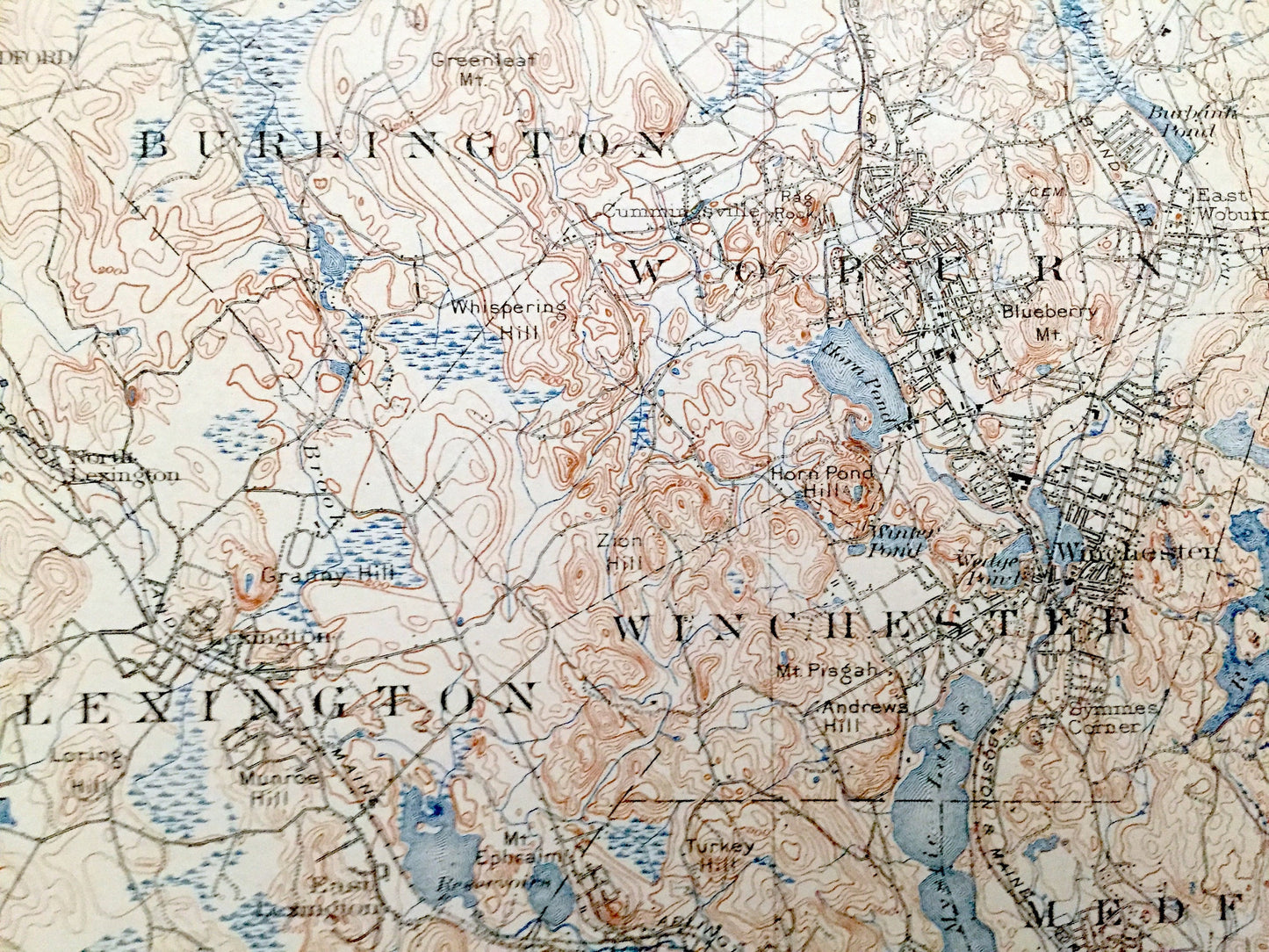
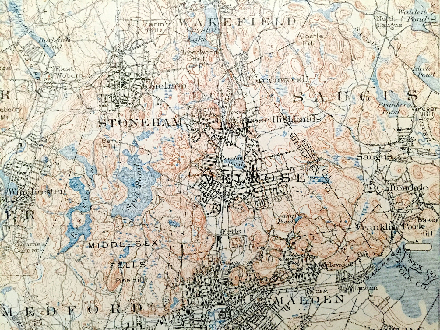
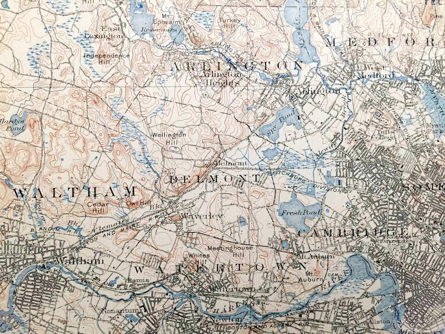
See what Boston looked like 120 years ago, before the land was fully developed. Lots of intricate details and geological contours. Map even has little squares for every house that existed at the time. The USGS cartographers were very thorough back then! On the back is a description of topographic symbols and map guide.
Perfect for the historian, map-lover, the curious or just as a conversation starter. Wonderful and rare. Vintage maps such as these make great gifts.
Edition of 1903, printed 1918
Dimensions: 16 1/2" width x 20" height
----
Features
Cities & Towns: Burlington, Lexington, Woburn, Winchester, Medford, Stoneham, Wakefield, Melrose, Saugus, Revere, Waltham, Arlington, Watertown, Belmont, Somerville, Cambridge, Everett, Chelsea, Charlestown, Newton, Needham, Dedham, Brookline, Boston, Hyde Park, Milton, Quincy, Cummingsville, North Lexington, East Lexington, East Woburn, West Medford, East Medford, North Saugus, Greenwood, Melrose Highlands, Wyoming, Oak Grove, Maplewood, Linden, Franklin Park, Cliftondale, Arlington Heights, Waverly, Nonantum, Auburndale, West Newton, Newtonville, Hills Crossing, Old Cambridge, Brighton, Allston, Longwood, Orient Heights, East Boston, South Boston, City Point, Newton Center, Newton Highlands, Thompsonville, Highlandville, Needham, Newton Upper Falls, Dedham Village, Boylston, Roxbury, Jamaica Plain, Forest Hills, Roslindale, West Roxbury, East Dedham, Hazelwood, Clarendon Hills, Mount Hope, Mattapan, Milton Upper Mills, Washington Village, Dorchester, Neponst, Lower Mills, Milton Mills, Atlantic, Wallaston.
Points of Interest: Middlesex County, Essex County, Norfolk County, Suffolk County, Boston Harbor, Charles River, Mystic River, Fresh Pond, South Bay, Back Bay, Spy Pond, Mystic Lakes, Spot Pond, Neponset River, Horn Pond, Chestnut Hill Reservoir, Harvard University, Fort Winthrop, Castle Island, Thompson Island, Squantum, Quincy Bay, Commercial Point, Dorchester Bay, Crystal Lake, Horn Pond Hill, Mt. Ephraim, Loring Hill, Pranker Pond, Penny Brook, Saugus River, Mystic Park, Tufts College, Clarendon Hill, Granny Hill, Whispering Hill, Cedar Hill, Owl Hill, Walnut Hill, Bald Pate Hill, Mt. Auburn Cemetery, Beacon Hill, Boston Common, Savin Hill, Breeds Island, Malden River, Zions Hill, High Rock, US Marine Hospital, Middlesex Fells, New York New Hampshire & Hartford Railroad, Boston & Albany Railroad, Boston & Maine Railroad and lots more creeks, hills, mountains, houses, churches, schools, cemeteries, train tracks and roads.
Condition: Good Vintage condition, commensurate with age. This map is in great shape for being over 100 years old. Has light edge-wear and folds as-issued, but these will flatten easily and all will add to vintage character when framed.
----
We will happily adjust shipping price for multiple purchases. Maps are rolled up and shipped in sturdy mailing tubes, never folded.
Couldn't load pickup availability
Share