My Store
Antique Chesapeake Bay, Maryland 1915 US Geological Survey Topographic Map – Rock Hall Baltimore Abingdon Aberdeen Tolchester Kent County MD
Antique Chesapeake Bay, Maryland 1915 US Geological Survey Topographic Map – Rock Hall Baltimore Abingdon Aberdeen Tolchester Kent County MD
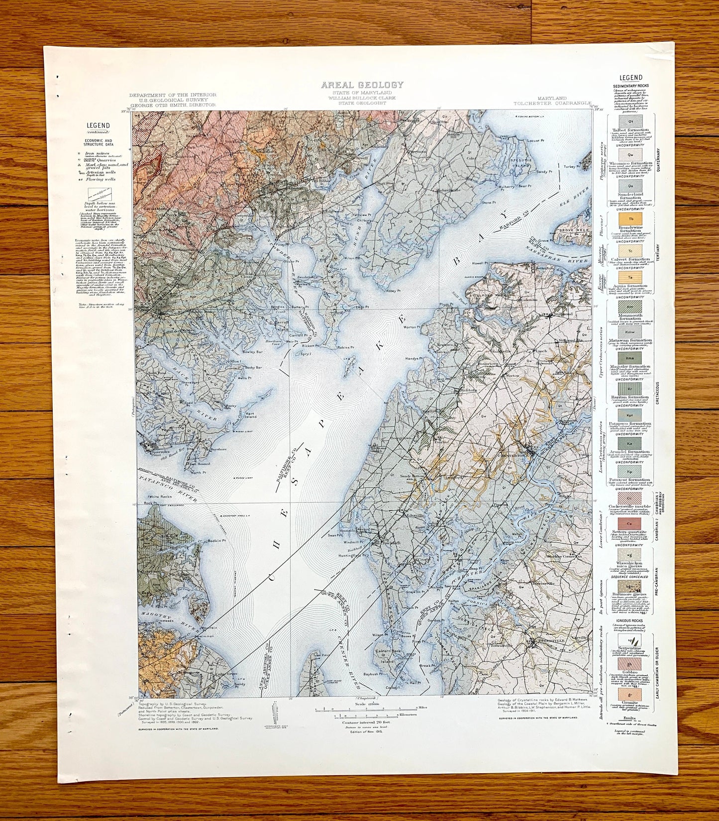
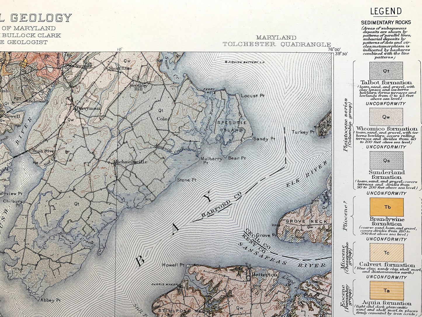
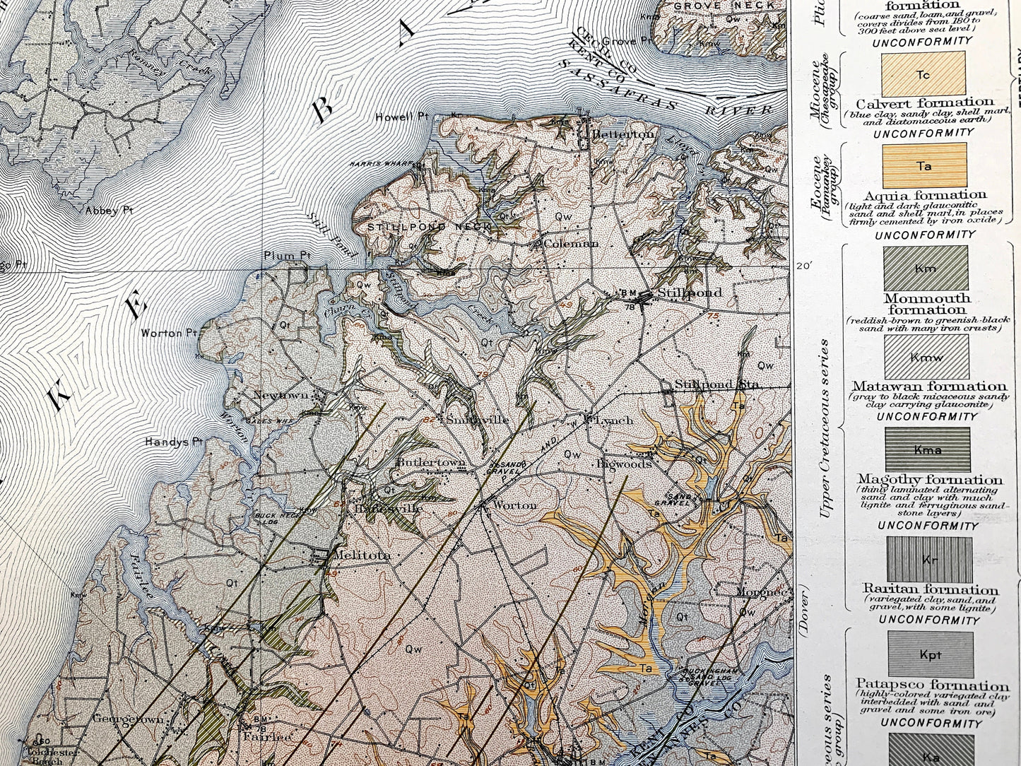
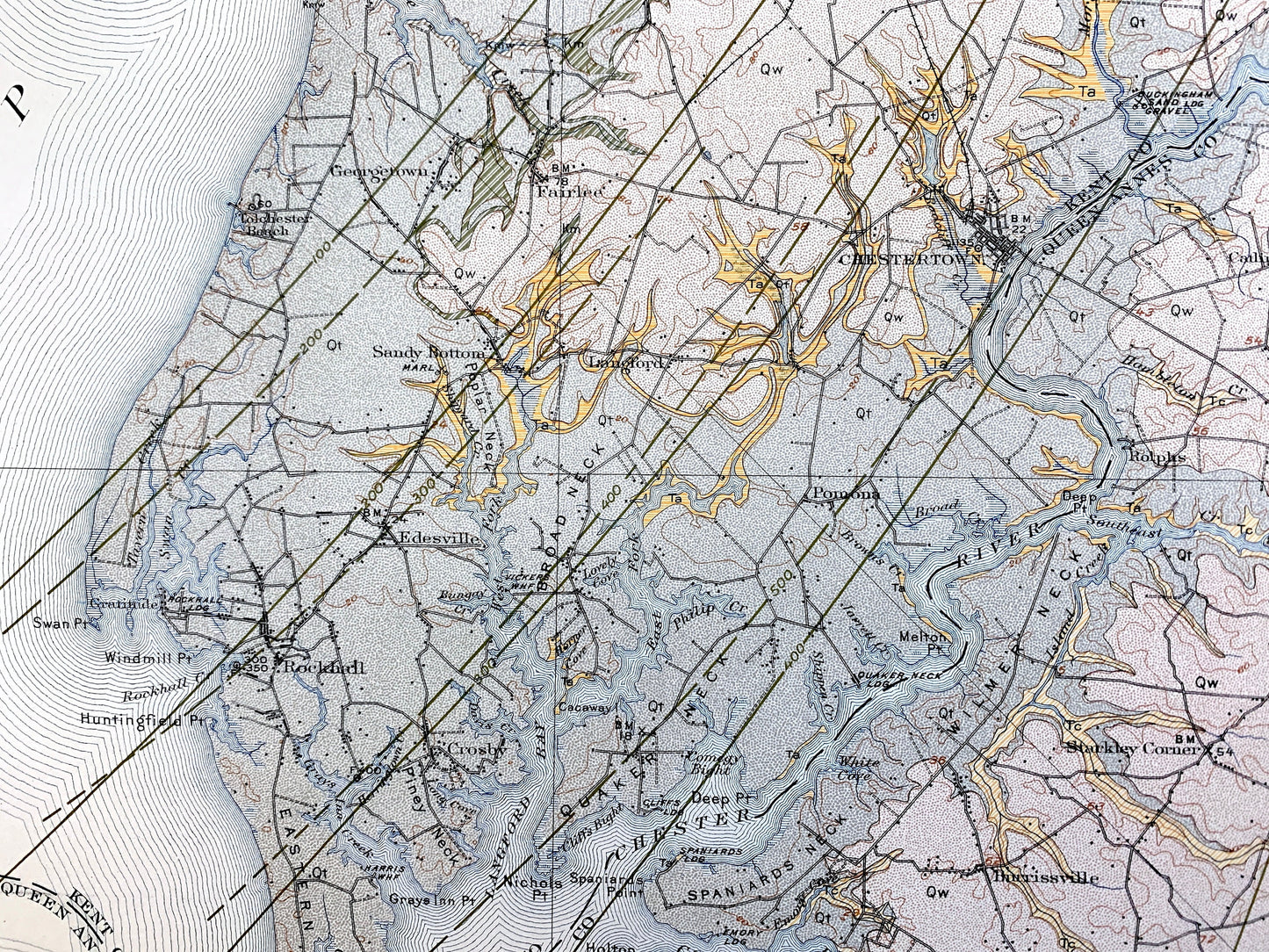
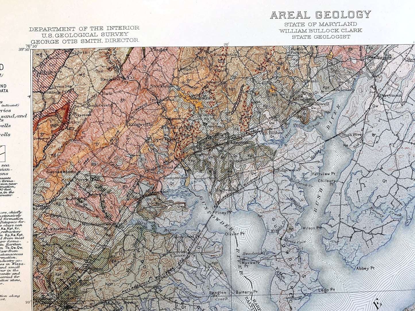
Beautiful, antique Areal Geology map of Chesapeake Bay, from Halls Crossroads and Elk River in the North to Rock Hall and Kent Island in the South. This is an authentic 1915 edition, 1915 print from the U.S. Geological Survey and NOT a computer reproduction. It is from a Geologic Atlas folio.
See what The Cheseapeake looked like 110 years ago. Places have disappeared or completely changed in the Bay since then. Lots of intricate details and geological contours. Map even has little squares for every house that existed at the time. The USGS cartographers were very thorough back then! This is one of the rare maps where the topographic symbols and map guide are on the front.
Perfect for the historian, map-lover, the curious or just as a conversation starter. Wonderful and rare. Vintage maps such as this make great gifts.
Edition of 1915, printed 1915
Dimensions: 18 1/2" width x 22" height
----
Cities & Towns: Bel Air, Abingdon, Halls Crossing, Worton, Kennedybille, Cecilton, Fairlee, Chestertown, Rock Hall, Pomona, Centerville, Queenstown, Hydes, Baldwin, Glenarm, Mountvista, Franlinville, Jerusalem, Joppa, Bradwhaw, Gunpower, Van Bibber, Bush, Sewell, Belcamp, Perryman, Short Line, Cole, Michaelsville, Upper Falls, Kingsville, Germantown, Perry Hall, Necker, Singer, Wheel, Emmorton, Harford Furnace, Poplar, Loreley, Rossville, Golden Ring, Walters, Bengies, North Point, Grange, Firzell, Sparrow Point, Bayshore, Fort Howard, Lakeshore, Mt. Carmel, St. Margarets, Cedar Grove, WInchester, Steppey, Short Line, Boothby Hill, Perryman, Coleman, Stillpond, Newtown, Smithville, Butlertown, Hanesville, Melitota, Worton, Bigwoods, Lynch, Morgnec, Georgetown, Tolchester Beach, Sandy Bottom, Langford, Rolphs, Edesveille, Gratitude, Crosby, Catlin, Starkley Corner, Burrissville, Brownsville.
Points of Interest: Chesapeake Bay, Elk River, Sassafras River, Bush River, Gunpowder River, Middle River, Back River, Patapsco River, Magothy River, Chester River, Fishing Battery Lighthouse, Grove Neck, Elk Neck, Spesutie Island, Gunpowder Neck, Bird River, Otter Point Creek, Back River Neck, Patapsco Neck, Old Road Bay, Bodking Point, Range Light, Sevenfoot Knoll Lighthouse, Kent Island, Eastern Neck Island, Corisica Neck, Lanford Bay, Piney Neck, Rockhall Creek, Rockhall Lodge, Swan Creek, Fairlee Creek, and many more small towns, roads, creeks, rivers, bays, islands, train tracks, schools, mills, hills.
Condition: Good Vintage condition, commensurate with age. This map is in great shape for being over 100 years old. Has light edge-wear and staple holes along the left margin, but this will add to vintage character when framed.
----
We will happily adjust shipping price for multiple purchases. Maps are rolled up and shipped in sturdy mailing tubes, never folded.
Couldn't load pickup availability
Share