My Store
Antique Hempstead, New York 1903 US Geological Survey Topographic Map – Long Island, Nassau County, Freeport, Mineola, Oceanside Woodmere NY
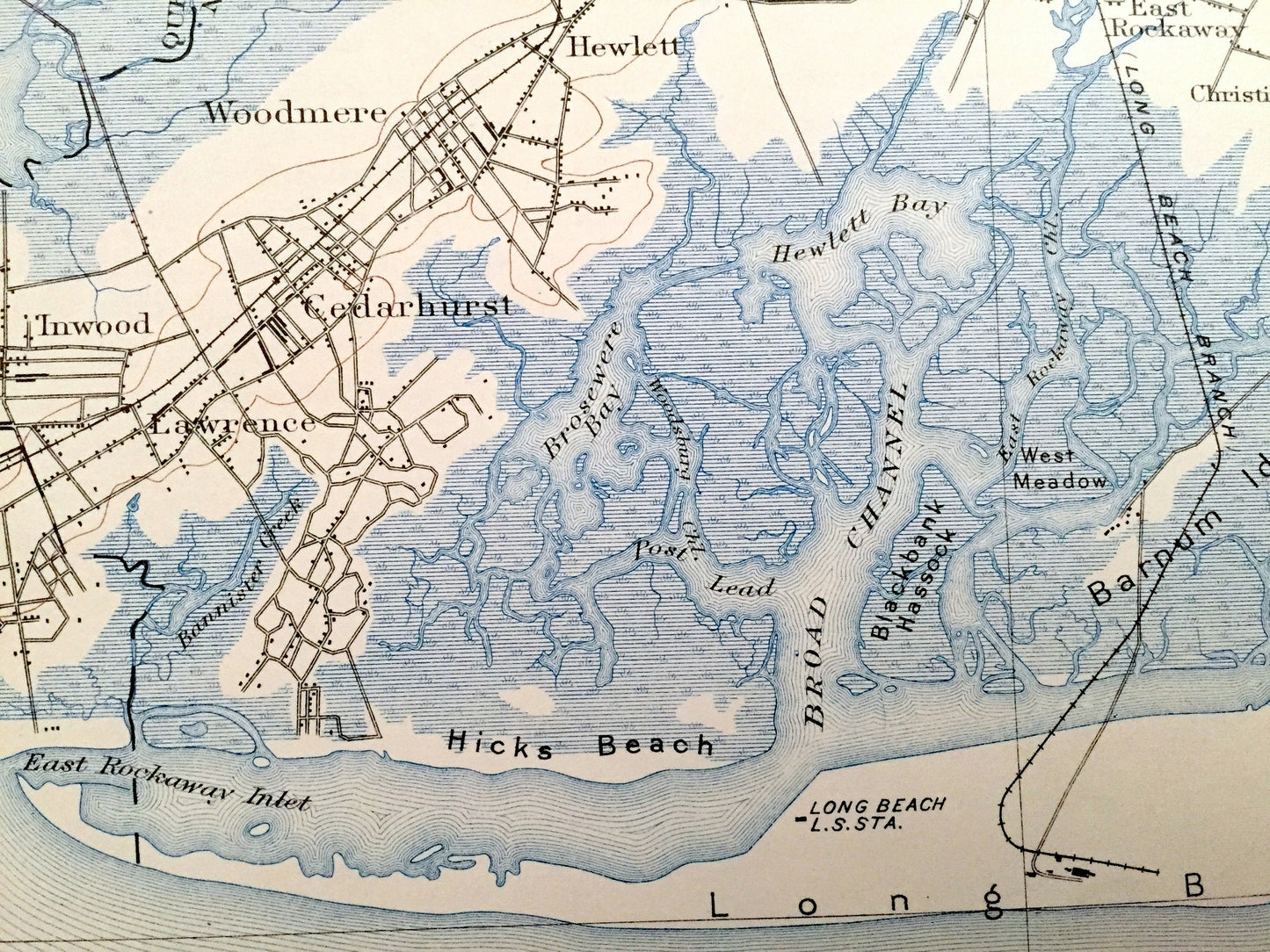
Antique Hempstead, New York 1903 US Geological Survey Topographic Map – Long Island, Nassau County, Freeport, Mineola, Oceanside Woodmere NY
Beautiful, antique map of Hempstead, New York and surrounding Nassau County area on Long Island. This is an authentic 1903 edition, 1929 print from the U.S. Geological Survey and NOT a computer reproduction.
See what Long Island looked like over 115 years ago, before a lot of the land was developed. Lots of intricate details and geological contours. Map even has little squares for every house that existed at the time. The USGS cartographers were very thorough back then! On the back is a description of topographic symbols and map guide.
Perfect for the historian, map-lover, the curious or just as a conversation starter. Wonderful and rare. Vintage maps such as these make great gifts.
Edition of 1903, printed 1929
Dimensions: 16 1/2" width x 20" height
----
Features
Cities & Towns: Hempstead, North Hempstead, Oyster Bay, Queens, Creedmoor, Floral Park, New Hyde Park, Elmont, Franklin Square, Munson, Fosters Meadows, Springland, Valley Stream, Mineola, Garden City, Norwood, Greenwich Point, Wantagh, Bellmore, Rosedale, Lynbrook, Woodmere, Hewlett, Inwood, Cedarhurst, Lawrence, Rockville Center, Baldwin, East Rockaway, Oceanside, Millburn, Christian Hook, Freeport, Merrick.
Points of Interest: Nassua County, Long Island, Long Beach, Far Rockaway Beach, Hicks Beach, Shelter Island, Broad Channel, Brosewere Bay, Hewlett Bay, Great Bar Hassock, Bay of Far Rockaway, Cape Toon Point, Middle Bay, Long Beach Channel, Sand Creek Meadow, East Bay, Merrick Bay, Short Beach, Jones Island, Crow Island, Hempstead Reservoir, Valley Stream Pond, False Channel Meadow, Neds Meadow, Long Island Railroad, and lots more creeks, marshes, islands, houses, schools, churches, train tracks and roads.
Condition: Good or "Very Vintage" condition, commensurate with age. This map is in great shape for being over 90 years old. Has some edge-wear, foxing, stain in bottom right corner and writing in corner margins, but this will add to vintage character when framed.
----
We will happily adjust shipping price for multiple purchases. Maps are rolled up and shipped fully-insured in sturdy mailing tubes, never folded.
Couldn't load pickup availability
Share