My Store
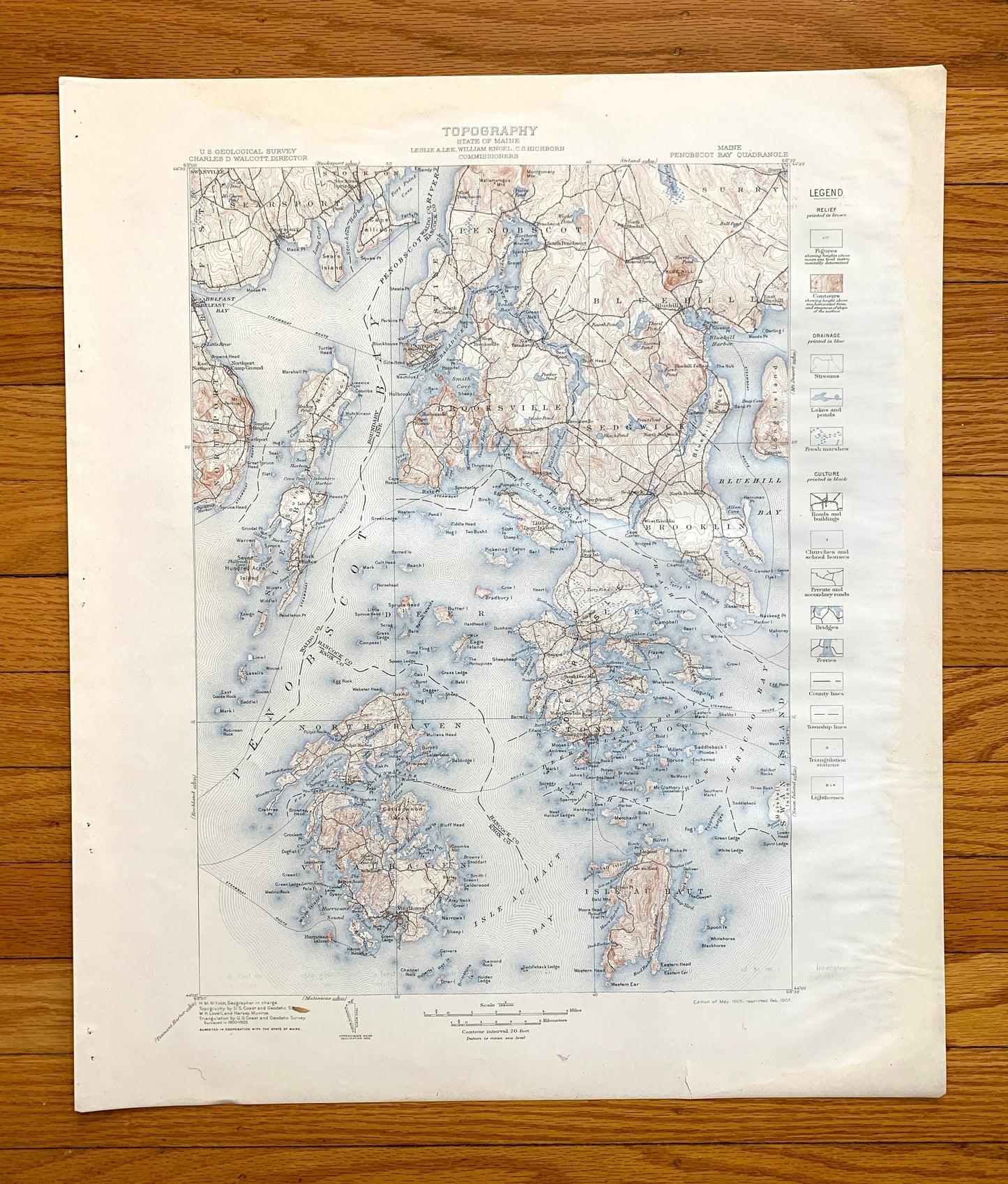
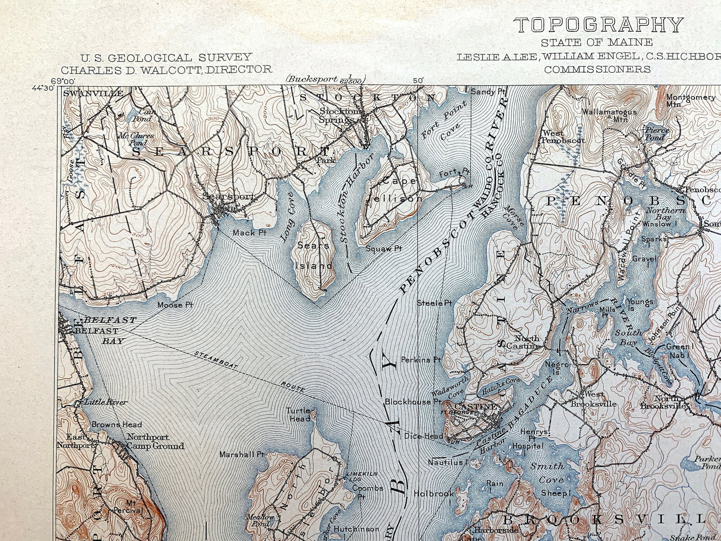
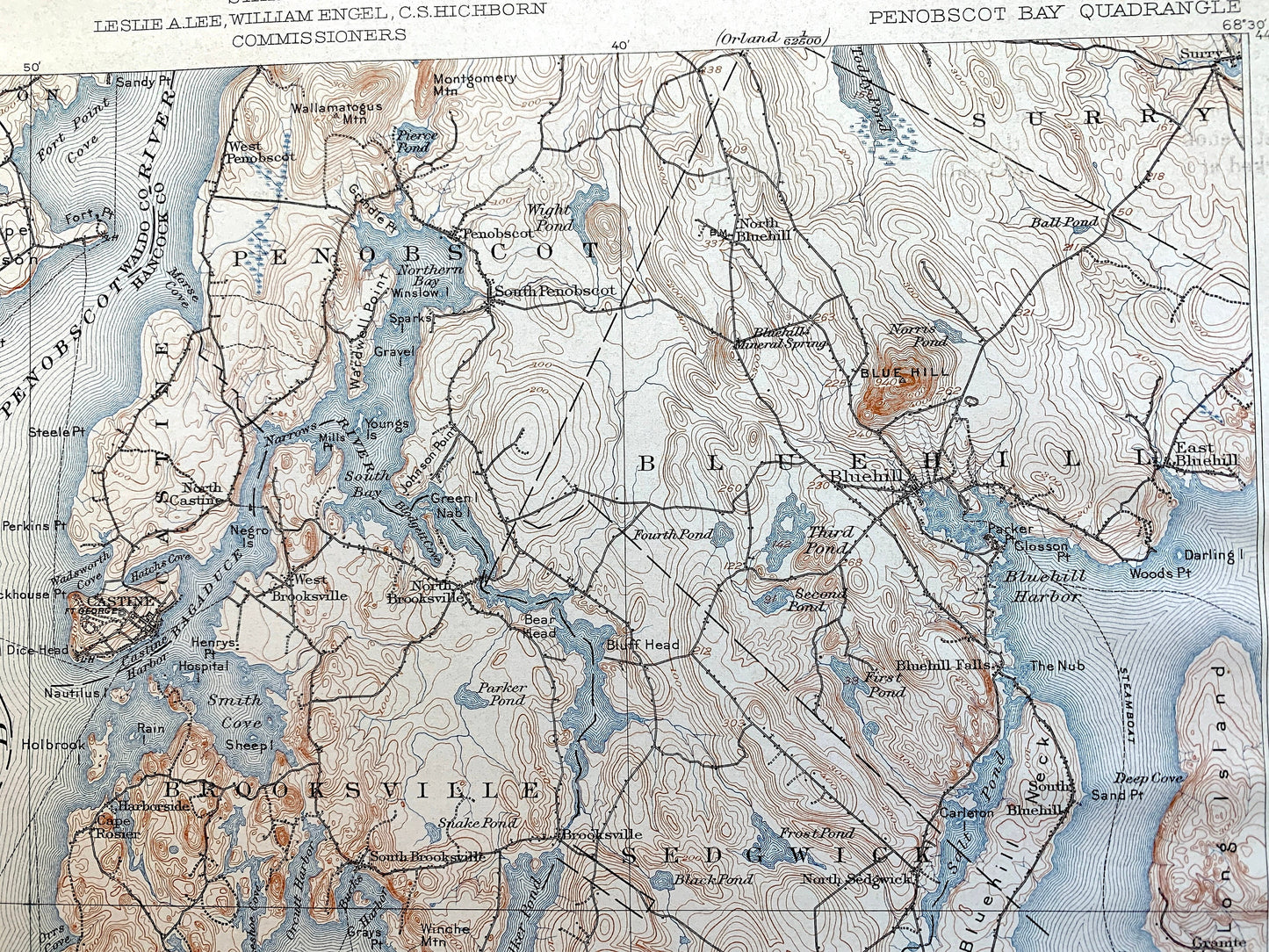
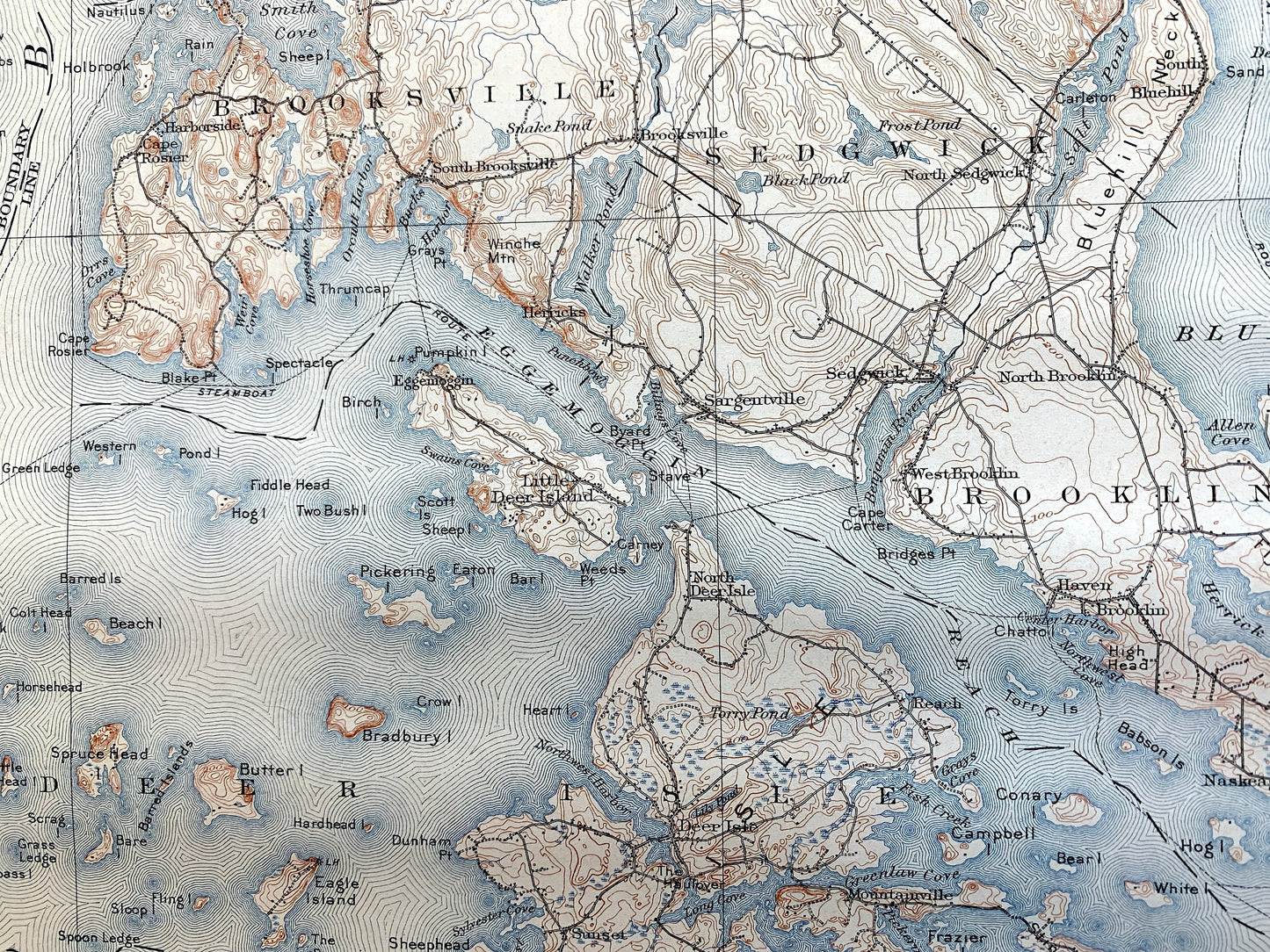
Antique Penobscot Bay, Maine 1905 US Geological Survey Topographic Map – Deer Isle, Searsport, Vinalhaven, Blue Hill, Sedgwick, Castine ME
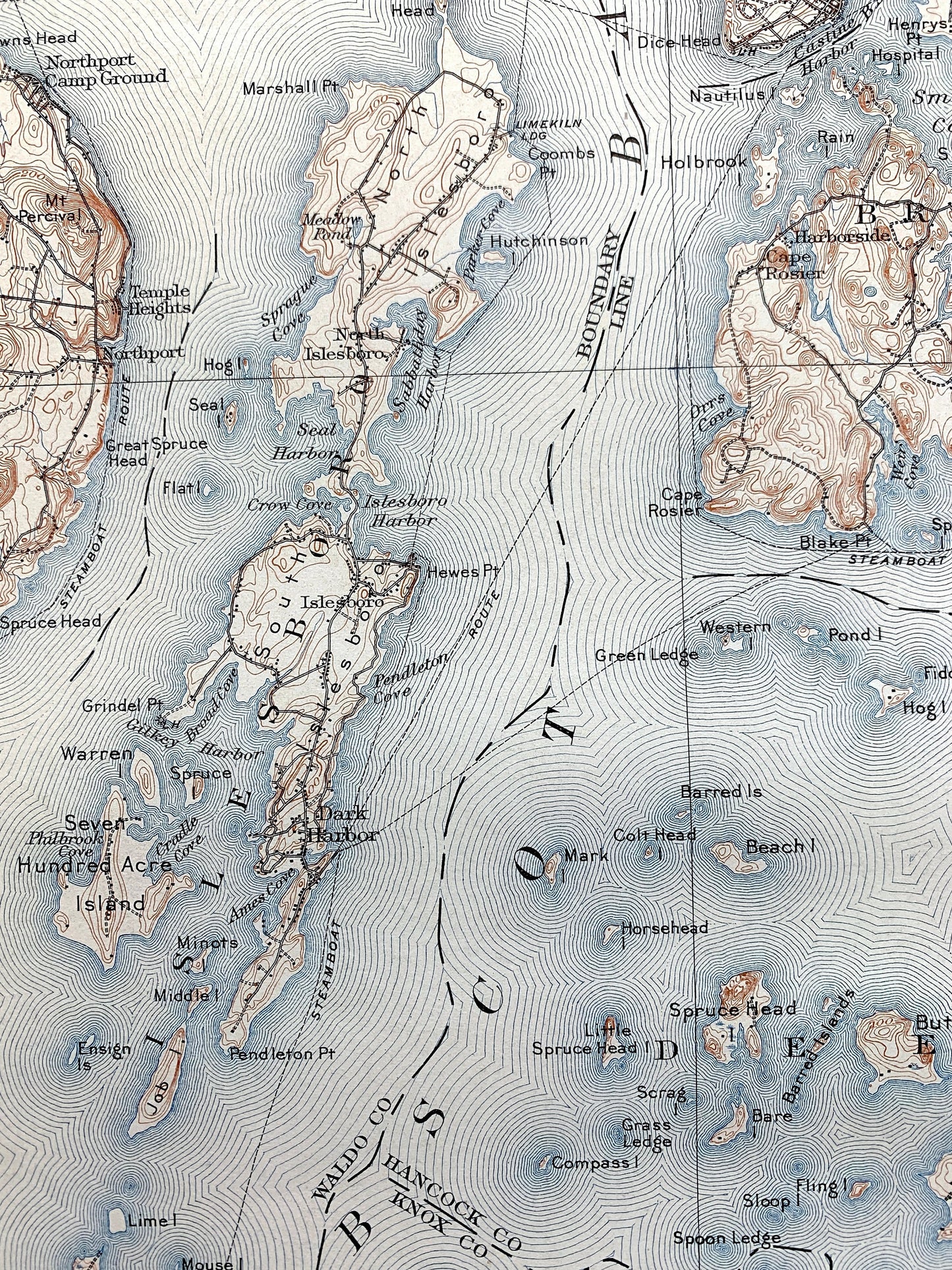
Antique Penobscot Bay, Maine 1905 US Geological Survey Topographic Map – Deer Isle, Searsport, Vinalhaven, Blue Hill, Sedgwick, Castine ME
Beautiful, antique map of Penobscot Bay, Maine and the islands of Knox, Waldo & Hancock Counties. This is an authentic 1905 edition, 1907 print from the U.S. Geological Survey and NOT a computer reproduction. It is from a Geologic Atlas folio.
See what the Maine Coast looked like over 115 years ago. Lots of intricate details and geological contours. Map even has little squares for every house that existed at the time. The USGS cartographers were very thorough back then! This is one of the rare maps where the topographic symbols and map guide are on the front.
Perfect for the historian, map-lover, the curious or just as a conversation starter. Wonderful and rare. Vintage maps such as these make great gifts.
Edition of 1905, printed 1907
Dimensions: 18 1/2" width x 22" height
----
Features
Cities & Towns: Isleboro, Deer Isle, North Haven, Vinalhaven, Pulpit Harbor, Hurricane Island, Belfast, Swanville, Searsport, Stockton, Northport, Penobscot, Castine, Brooksville, Blue Hill, Surry, Sedgwick, Brooklin, Stonington, Swan Island, East Northport, North Isleboro, Stockton Springs, Park, Temple Heights, West Penobscot, North Castine, West Brooksville, Cape Rosier, Harborside, Dark Harbor, Sargentville, Little Deer Island, Sunset, Haven, Naskeag, Reach, Mountainville, Oceanville, Sunshine, Lookout, Isle Au Haut.
Points of Interest: Knox County, Waldo County, Hancock County, Penobscot Bay, Jericho Bay, Bluehill Bay, Belfast Bay, Eggemoggin Reach, Bluehill Harbor, Penobscot River, Bagaduce River, Castine Harbor, Northern Bay, Walker Pond, North Islesboro, South Islesboro, Smith Cove, Long Island, Blue Hill, Flye Point, Bluehill Neck, Stinson Neck, Marshall Island, Kimball Island, Eagle Island, Butter Island, Ducktrap Harbor, Island Thorofare, Isle Au Haut Bay, Southern Harbor, Little Thorofare, Hurricane Sound, Winter Harbor, Seal Bay, Mill River, Seven Hundred Acre Island, South Isleboro, Job Island, Butter Island, Barred Islands, Spruce Head Island, Eagle Island, Hardhead Island, The Porcupines, Oak Hill, Webster Head, Egg Rock, Bartlett Harbor, Wooster Cove, Crabtree Point, Kent Cove, Perry Cove, Seal Cove, Calderwood Neck, Long Island, Bluff Head, Coombs Hill, Leadbetter Island, Lairey Narrows, White Islands, Old Harbor, Green Island, Sand Cove, Indian Creek, Roberts Harbor, Arey Neck, Sheep Island, Channel Rock, Diamond Island and lots more hills, streams, ponds, islands, houses, islands, harbors, coves, roads, railroads.
Condition: Good Vintage condition, commensurate with age. This map is in great shape for being over 115 years old. Some light wear, a stain along the top and rightmargin, staple holes in the margin, as well as some warbling in the right section of the map, but this will flatten easily and all will read as vintage character when framed.
----
We will happily adjust shipping price for multiple purchases. Maps are rolled up and shipped in sturdy mailing tubes, never folded.
Couldn't load pickup availability
Share