My Store
Antique York, Maine 1920 US Geological Survey Topographic Map – Wells, Kittery, York Beach, Portsmouth, Rye, New Castle, New Hampshire ME NH
Antique York, Maine 1920 US Geological Survey Topographic Map – Wells, Kittery, York Beach, Portsmouth, Rye, New Castle, New Hampshire ME NH
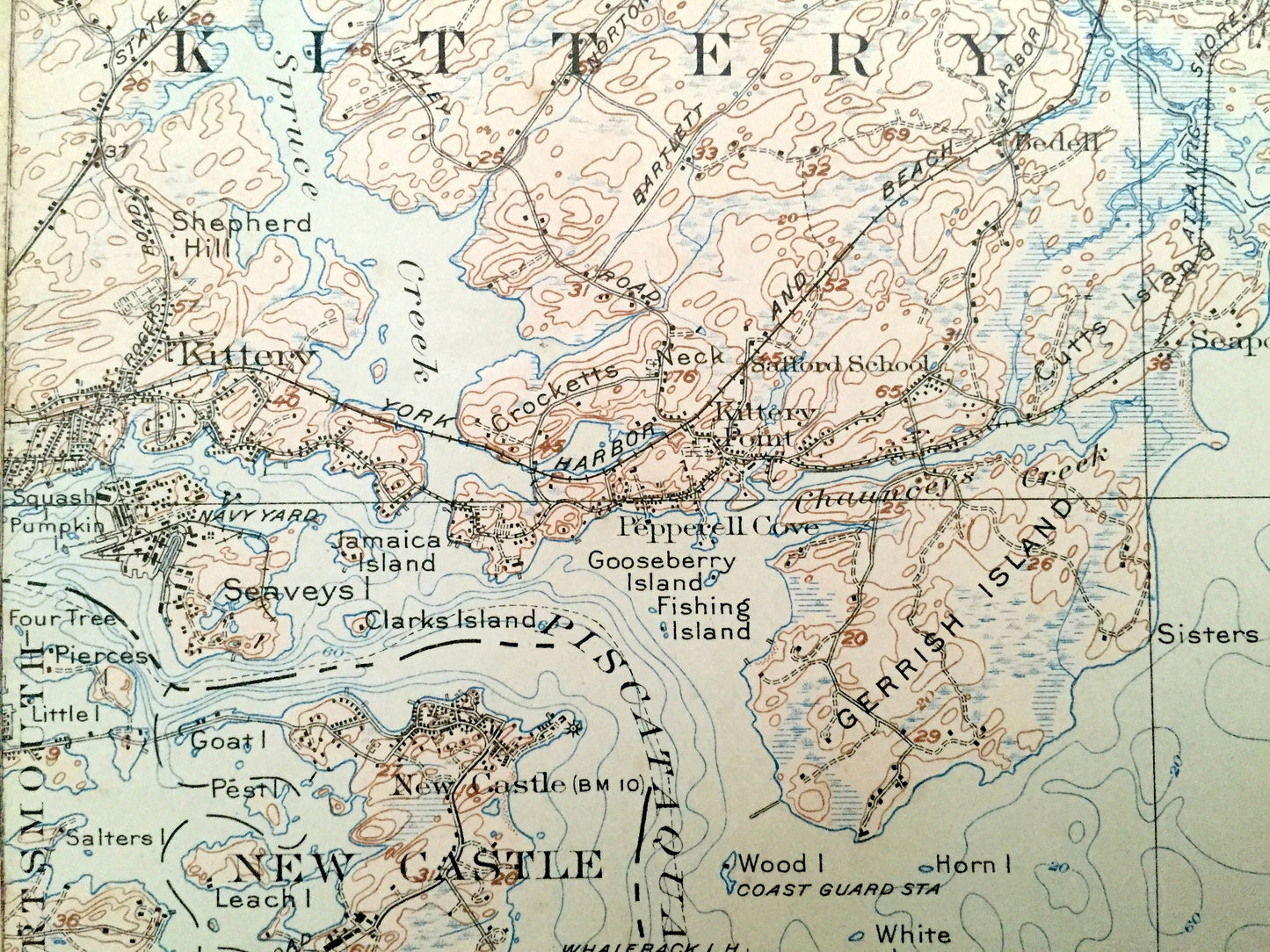
Beautiful, antique map of Portsmouth, New Hampshire and York, Wells, Kittery, Maine & Rye, New Hampshire area on the Atlantic Coast. This is an authentic 1920 edition, 1925 print from the U.S. Geological Survey and NOT a computer reproduction.
See what Rockingham County, New Hampshire and York County, Maine looked like 100 years ago. Lots of intricate details and geological contours. Map even has little squares for every house that existed at the time. The USGS cartographers were very thorough back then! On the back is a description of topographic symbols and map guide.
Perfect for the historian, map-lover, the curious or just as a conversation starter. Wonderful and rare. Vintage maps such as these make great gifts.
Edition of 1920, printed 1925
Dimensions: 16 1/2" width x 21" height
----
Features
Cities & Towns: MAINE: South Berwick, York, Wells, Kittery, Emorys Bridge, Brixham Grange, Payneton, Scituate, Ogunquit, Walnut Hill, High Pasture, Bald Head, Cape Neddick, York Beach, Concordville, Summit, Scotland, Beach Ridge, Cooks Bridge, Langleys Crossing, Barrell Farm, Kittery Point, Bedell, York Village, York Corner, Oceanside, Long Beach, Oakland Farm, Seapoint, York Heights, Pepperell Cove, Passaconway.
NEW HAMPSHIRE: Portsmouth, New Castle, Rye, Rye North Beach.
Points of Interest: Atlantic Coast, York River, Spruce Creek, Piscataqua River, Josias River, Chases Pond, Cape Neddick River, Bald Head Cliff, Pond Rocks, Cape Neddick, Long Beach, Stage Neck, York Harbor, Weare Point, Dolly Gordon Brook, Gerrish Island, Cutts Island, Godfreys Cove, Brave Boat Harbor, Sisters Point, Appledore Island, Shag Rock, Duck Island, Mingo Rock, Little Harbor, Sheafes Point, Frost Point, Goose Island, Four Tree Island, Squash Pumpkin Island, Wallis Sands, Ragged Neck Point, Odiornes Point, Boon Island Lighthouse, Star Island, Isles of Shoals Lighthouse, Argo Point, Seal Head Point, Mt. Agamenticus, York Woods, Works River, York Harbor & Beach Railroad, Atlantic Shore Electric Railroad, and lots more hills, mountains, streams, ponds, marshes, camps, houses, islands, coves, roads, railroads.
Condition: Fair or "Very Vintage" condition, commensurate with age. This map is in great shape for being over 95 years old. Has edge-wear, spots, pin holes, discoloration, toning and pencil in margins, but this will all add to its uniqueness and vintage character when framed.
----
We will happily adjust shipping price for multiple purchases. Maps are rolled up and shipped in sturdy mailing tubes, never folded.
Couldn't load pickup availability
Share