My Store
Antique Yosemite National Park, California 1958 US Geological Survey Topographic Map – Hetch Hetchy, Stanislaus, Toiyabe, Inyo Forest, CA
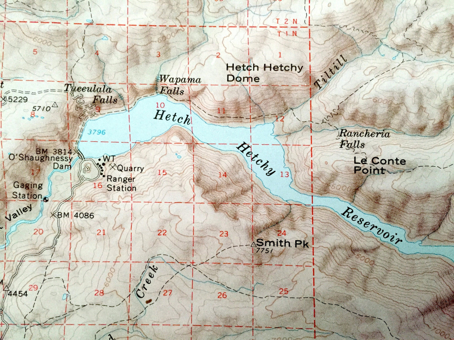
Antique Yosemite National Park, California 1958 US Geological Survey Topographic Map – Hetch Hetchy, Stanislaus, Toiyabe, Inyo Forest, CA
Beautiful, massive, antique map of Yosemite National Park, including Sierra National Forest, Stanislaus National Forest, Toiyabe National Forest & Inyo National Forest. This is an authentic 1958 edition, 1969 print from the U.S. Geological Survey and NOT a computer reproduction.
The USGS only printed a small number of these maps centered around specific geological points of interest. The entire National Park is pictured. In a normal USGS map it would be divided into many smaller maps because of its immensity. It is one of the largest maps in my collection—2 1/2 feet by 2 1/2 feet—and is stunning in its presentation and detail since it is still at 1:125000 scale. This map will be the centerpiece and focus of whatever room it is hung in.
See what Yosemite looked like over 60 years ago. Lots of intricate details and geological contours. Map even has little squares for every house and building that existed at the time. The USGS cartographers were very thorough back then!
Perfect for the historian, map-lover, the curious or just as a conversation starter. Wonderful and rare. Vintage maps such as these make great gifts.
Edition of 1958, printed 1969
Dimensions: 31" width x 32" height
----
Features
Cities & Towns: Pinecrest, Lundy, Willow Springs, Mono Village, Mather, Harden Flat, Aspen Valley, White Wolf, Mono Lake, Lee Vining, Rush Creek, El Portal, Yosemite Village, Foresta, Badger Pass, Camp Curry, June Lake Junction, Briceburg, Mariposa, Timber Lodge, Midpines, Las Mariposas, Big Tree, Darrah, Wawona, North Wawona, South Wawona, Fish Camp.
Points of Interest: Mariposa County, Madera County, Mono County, Tuolumne County, Yosemite National Park, Sierra National Forest, Stanislaus National Forest, Toiyabe National Forest, Inyo National Forest, Devils Postpile National Monument, Yosemite Valley, Mono Lake, Hetch Hetchy Reservoir, Twin Lakes, Cherry Lake, Lake Eleanor Reservoir, Grand Canyon of the Tuolumne River, Eagle Peak, Tower Peak, Twin Peaks, Half Dome, Mount Dana, Mount Lyell, Cathedral Range, Lyell Canyon, Ritter Range, Pumice Valley, Mono Craters, Bridgeport Valley, Clark Range, Kibbie Ridge, Tuolumne River, Merced River, Tuolumne Meadows, and many more mountains, peaks, ranges, canyons, buttes, crests, rivers, creeks, lakes, ponds, springs, trails, campgrounds, caves, valleys, hills, towns, roads and train tracks.
Condition: Very Good Vintage condition, commensurate with age. This map is in incredible shape for being over 50 years old. Has some light edge-wear and folds as-issued, but these will flatten easily and all will read as vintage character when framed.
----
We will happily adjust shipping price for multiple purchases. Map will be shipped folded to preserve quality.
Couldn't load pickup availability
Share